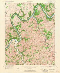
1952 Map of Valley View
USGS Topo · Published 1968About this map
The Kentucky River carves a deep, winding path through the borderlands of Fayette, Jessamine, and Madison counties, defining the isolated geography of this rural 1950s landscape. Near the river's sharpest bends, the settlement of Valley View serves as a focal point, while the YMCA Camp occupies a prominent peninsula within the river's loop. The area is characterized by a high density of rural institutions, including the Woodland Heights School and multiple churches like Cuzick Ch and Forest Hill Ch, which anchored these upland farming communities.
Find a feature on this map
34 named features on this map. Tap any name to fly to it.
Don’t see what you’re looking for? This feature index may not catch every label — zoom into the map to look around manually.
Map Details
Editions of this 1952 Valley View Map
3 editions found
Other maps of this area

1892 · Richmond
USGS Topo · 1:125,000

1897 · Richmond
USGS Topo · 1:125,000

1905 · Harrodsburg
USGS Topo · 1:125,000

1952 · Valley View
USGS Topo · 1:24,000

1952 · Little Hickman
USGS Topo · 1:24,000

1952 · Nicholasville
USGS Topo · 1:24,000

1952 · Buckeye
USGS Topo · 1:24,000

1952 · Coletown
USGS Topo · 1:24,000

1952 · Kirksville
USGS Topo · 1:24,000

1952 · Ford
USGS Topo · 1:24,000