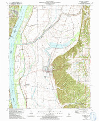
1991 Map of Valmeyer
USGS Topo · Published 1991About this map
Valmeyer sits at the foot of the bluffs in Monroe County, Illinois, serving as a focal point for this landscape just before major flooding reshaped its history. The village is positioned where the Missouri Pacific Railroad skirts the edge of the upland terrain, separating the flat agricultural bottomlands from the higher elevations of Potato Hill and Dennis Hollow. Along the Mississippi River, the boundary between Illinois and Missouri is defined by features like Chesley Island and Meissner Island, while the western shore is home to the historic settlements of Kimmswick and Sulphur Springs. Local history is deeply etched into the hillsides at Eagle Cliff Cem and Wallace Cem, as well as the small riverside community at Harrisonville. The map also details the rural infrastructure of the early 1990s, including Jacobs Landing Strip and several Quarries that reflect the area's geological utility.
Find a feature on this map
37 named features on this map. Tap any name to fly to it.
Don’t see what you’re looking for? This feature index may not catch every label — zoom into the map to look around manually.
Map Details
Editions of this 1991 Valmeyer Map
This is the sole edition of this map. No revisions or reprints were ever made.
Other maps of this area

1910 · Waterloo
USGS Topo · 1:62,500

1912 · Kimmswick
USGS Topo · 1:62,500

1913 · Waterloo
USGS Topo · 1:62,500

1915 · Renault
USGS Topo · 1:62,500

1915 · Crystal City
USGS Topo · 1:62,500

1916 · Kimmswick
USGS Topo · 1:62,500

1940 · Renault
USGS Topo · 1:62,500

1948 · Kimmswick
USGS Topo · 1:62,500

1949 · Saint Louis
USGS Topo · 1:250,000

1949 · Crystal City
USGS Topo · 1:62,500