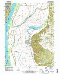
1993 Map of Valmeyer
USGS Topo · Published 1996About this map
Valmeyer and Harrisonville occupy the fertile bottomlands of the Mississippi River in this early 1990s revision, just before significant environmental changes altered the local landscape. The map captures the traditional settlement pattern of Monroe County, where communities like Fountain and Monroe City are connected by a network of rural routes such as Garleb Road and Baer Road. The St Louis Southwestern RR cuts a straight line through the floodplain, serving the industrial interests represented by local Quarries.
Find a feature on this map
38 named features on this map. Tap any name to fly to it.
Don’t see what you’re looking for? This feature index may not catch every label — zoom into the map to look around manually.
Map Details
Editions of this 1993 Valmeyer Map
This is the sole edition of this map. No revisions or reprints were ever made.
Other maps of this area

1910 · Waterloo
USGS Topo · 1:62,500

1912 · Kimmswick
USGS Topo · 1:62,500

1913 · Waterloo
USGS Topo · 1:62,500

1915 · Renault
USGS Topo · 1:62,500

1915 · Crystal City
USGS Topo · 1:62,500

1916 · Kimmswick
USGS Topo · 1:62,500

1940 · Renault
USGS Topo · 1:62,500

1948 · Kimmswick
USGS Topo · 1:62,500

1949 · Saint Louis
USGS Topo · 1:250,000

1949 · Crystal City
USGS Topo · 1:62,500