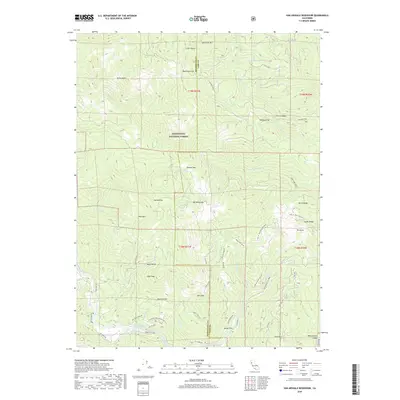
2018 Map of Van Arsdale Reservoir
USGS Topo · Published 2018About this map
Van Arsdale Reservoir and the winding course of the Eel River anchor this topographic study of the Mendocino and Lake County borderlands. The landscape is defined by the high elevations of the Mendocino National Forest, where peaks like Sanhedrin Mtn, High Peak, and Pine Mtn rise above a series of named flats and clearings. Historically, these remote pockets provided space for settlement and resource extraction, documented through names like Deadmans Flat, Jordan Flat, and Big Openings. The map traces a complex network of forest routes and historic pathways, including the Van Arsdale Pillsbury road and the Old Ukiah Pines Rd, which speak to the area's legacy of logging and backcountry transit. From the drainage of Tule Lake in the north to the meadows of Montgomery Glade in the south, the sheet provides a detailed accounting of the land's rugged character and its sparse, high-country outposts.
Find a feature on this map
60 named features on this map. Tap any name to fly to it.
Don’t see what you’re looking for? This feature index may not catch every label — zoom into the map to look around manually.
Map Details
Editions of this 2018 Van Arsdale Reservoir Map
This is the sole edition of this map. No revisions or reprints were ever made.
Other maps of this area

1922 · Hullville
USGS Topo · 1:62,500

1929 · Eden Valley
USGS Topo · 1:62,500

1943 · Pomo
USGS Topo · 1:62,500

1951 · Lake Pillsbury
USGS Topo · 1:62,500

1952 · Hull Mountain
USGS Topo · 1:62,500

1952 · Eden Valley
USGS Topo · 1:62,500

1957 · Ukiah
USGS Topo · 1:250,000

1960 · Ukiah
USGS Topo · 1:250,000
1960 · Potter Valley
USGS Topo · 1:24,000

1960 · Potter Valley
USGS Topo · 1:62,500