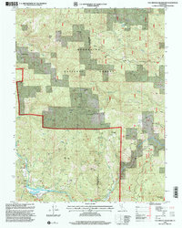
1996 Map of Van Arsdale Reservoir
USGS Topo · Published 2001About this map
Van Arsdale Reservoir and the Van Arsdale Dam dominate the southern landscape of this 1990s forest survey, where the Eel River is managed for regional water needs. The terrain is marked by remote outposts and family holdings such as Ascherman Ranch, Presley Ranch, and the Old Dashtell Place, reflecting the area's history of rural habitation within the Mendocino National Forest. The map details a complex network of high-elevation flats and ridges, including Deadmans Flat and Welch Ridge, interspersed with numerous seasonal springs. Infrastructure tied to the river's flow is evident at the Spillway and multiple Gaging Stations, while recreational or organizational sites like Hartstone Camp and a Mobile Home Park near the water indicate the intersection of wilderness and seasonal residence.
Find a feature on this map
41 named features on this map. Tap any name to fly to it.
Don’t see what you’re looking for? This feature index may not catch every label — zoom into the map to look around manually.
Map Details
Editions of this 1996 Van Arsdale Reservoir Map
This is the sole edition of this map. No revisions or reprints were ever made.
Other maps of this area

1922 · Hullville
USGS Topo · 1:62,500

1929 · Eden Valley
USGS Topo · 1:62,500

1943 · Pomo
USGS Topo · 1:62,500

1951 · Lake Pillsbury
USGS Topo · 1:62,500

1952 · Hull Mountain
USGS Topo · 1:62,500

1952 · Eden Valley
USGS Topo · 1:62,500

1957 · Ukiah
USGS Topo · 1:250,000

1960 · Ukiah
USGS Topo · 1:250,000
1960 · Potter Valley
USGS Topo · 1:24,000

1960 · Potter Valley
USGS Topo · 1:62,500