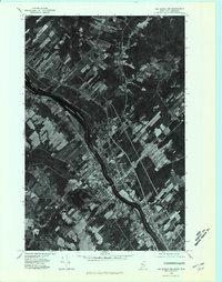
1975 Map of Van Buren NW
USGS Topo · Published 1981About this map
Van Buren and St Leonard face each other across the Saint John River, marking a prominent international crossing at the mid-1970s border between Maine and New Brunswick. This orthophotoquad provides an aerial view of the river-valley landscape, where the long, thin agricultural lots characteristic of early French-Acadian settlement patterns stretch back from the water toward the timbered uplands. The settlement at Keegan sits just northwest of the main town center, while numerous watercourses like Violette Stream and Violette Brook drain the Maine side into the Saint John. Across the water in Canada, the Grand River joins the primary channel, highlighting the importance of these waterways for transport and irrigation in this borderland farming community during the latter half of the twentieth century.
Find a feature on this map
10 named features on this map. Tap any name to fly to it.
Don’t see what you’re looking for? This feature index may not catch every label — zoom into the map to look around manually.
Map Details
Editions of this 1975 Van Buren NW Map
This is the sole edition of this map. No revisions or reprints were ever made.
Other maps of this area

1921 · Van Buren
USGS Topo · 1:250,000

1927 · Stockholm
USGS Topo · 1:48,000

1931 · Van Buren
USGS Topo · 1:48,000

1931 · Stockholm
USGS Topo · 1:62,500

1934 · Van Buren
USGS Topo · 1:62,500

1938 · Grand Isle
USGS Topo · 1:62,500

1940 · Grand Isle
USGS Topo · 1:62,500

1951 · Van Buren
USGS Topo · 1:62,500

1953 · Stockholm
USGS Topo · 1:62,500

1962 · Edmundston
USGS Topo · 1:250,000