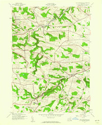
1943 Map of Van Hornesville
USGS Topo · Published 1960About this map
Van Hornesville and the winding course of Otsquago Creek anchor this survey of the New York uplands during the early 1940s. The landscape is defined by the rural townships of Stark, Danube, and Minden, where small dairy farms and crossroad hamlets like Starkville were connected by a network of unimproved dirt roads. Genealogists can identify numerous family-named landmarks and burial grounds, including Garlock Cem, Hawn Cem, and the uniquely named Pumpkin Hook Cem near the southern boundary.
Find a feature on this map
30 named features on this map. Tap any name to fly to it.
Don’t see what you’re looking for? This feature index may not catch every label — zoom into the map to look around manually.
Map Details
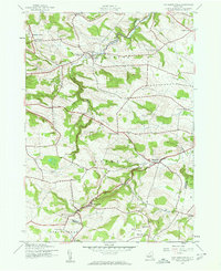
Editions of this 1943 Van Hornesville Map
2 editions found
Other maps of this area

1898 · Canajoharie
USGS Topo · 1:62,500

1900 · Little Falls
USGS Topo · 1:62,500

1900 · Canajoharie
USGS Topo · 1:62,500

1901 · Lassellsville
USGS Topo · 1:62,500

1902 · Canajoharie
USGS Topo · 1:62,500

1903 · Richfield Springs
USGS Topo · 1:62,500

1903 · Lassellsville
USGS Topo · 1:62,500

1903 · Little Falls
USGS Topo · 1:62,500

1939 · Little Falls
USGS Topo · 1:62,500

1943 · Jordanville
USGS Topo · 1:24,000