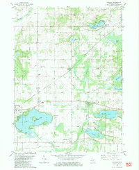
1981 Map of Vandalia
USGS Topo · Published 1982About this map
Vandalia sits at the intersection of the Grand Trunk Western railroad and an Old Railroad Grade, marking a landscape defined by glacial topography and early Michigan prairie settlements. The map highlights a chain of significant water bodies, most notably the large Diamond Lake with its prominent Diamond Island and the residential development at Diamond Shores. This early 1980s record captures the rural character of Cass County, showing a network of grid-patterned roads such as Dutch Settlement Street and Brownsville Street that connect historic pockets like Wakelee and Brownsville. Numerous small burial grounds, including Moon Cem and Youngs Prairie Cem, provide valuable data for genealogists tracing family names through these townships. The transition from active rail to retired grades reflects the changing transportation patterns of the late twentieth century.
Find a feature on this map
67 named features on this map. Tap any name to fly to it.
Don’t see what you’re looking for? This feature index may not catch every label — zoom into the map to look around manually.
Map Details
Editions of this 1981 Vandalia Map
This is the sole edition of this map. No revisions or reprints were ever made.
Other maps of this area

1927 · Hartford
USGS Topo · 1:62,500

1931 · Hartford
USGS Topo · 1:62,500

1944 · Marcellus
USGS Topo · 1:62,500

1945 · Cassopolis
USGS Topo · 1:62,500

1946 · Marcellus
USGS Topo · 1:62,500

1947 · Cassopolis
USGS Topo · 1:62,500

1948 · Vandalia
USGS Topo · 1:62,500

1949 · Vandalia
USGS Topo · 1:62,500

1953 · Fort Wayne
USGS Topo · 1:250,000

1953 · Chicago
USGS Topo · 1:250,000