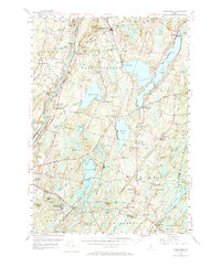
1956 Map of Vassalboro
USGS Topo · Published 1973About this map
The Kennebec River corridor defines the western edge of this mid-century landscape, passing through Riverside and Sevenmile while a network of large glacial lakes dominates the central and eastern sections. Established educational landmarks like the Oak Grove Seminary near Vassalboro and the Erskine Academy further east indicate the region's long-standing community centers. The map documents a transition from the industrial heritage of water-powered sites like Seaward Mills and Coopers Mills toward a post-war rural economy, where the Windsor Fairgrounds and the sprawling Veterans Administration Facility near Togus Pond serve as major regional hubs. Small, distinct neighborhoods such as Getchell Corner, Maccs Crossing, and Dirigo Corner are interspersed among numerous family cemeteries and local schools like Pigeon Plains Sch, reflecting a highly localized social geography that persisted before modern highway consolidation changed the character of these Maine towns.
Find a feature on this map
104 named features on this map. Tap any name to fly to it.
Don’t see what you’re looking for? This feature index may not catch every label — zoom into the map to look around manually.
Map Details
Editions of this 1956 Vassalboro Map
3 editions found
Other maps of this area

1892 · Gardiner
USGS Topo · 1:62,500

1892 · Waterville
USGS Topo · 1:62,500

1892 · Augusta
USGS Topo · 1:62,500

1893 · Vassalboro
USGS Topo · 1:62,500

1893 · Wiscasset
USGS Topo · 1:62,500

1894 · Norridgewock
USGS Topo · 1:62,500

1898 · Norridgewock
USGS Topo · 1:62,500

1898 · Vassalboro
USGS Topo · 1:62,500

1913 · Waldoboro
USGS Topo · 1:48,000

1915 · Waldoboro
USGS Topo · 1:62,500