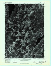
1975 Map of Vassalboro SE
USGS Topo · Published 1980About this map
The West Branch Sheepscot River carves a winding path through the heart of the Kennebec County landscape in the mid-1970s. This orthophotoquad captures a detailed aerial view of agricultural and woodland patterns centered around the village of Windsorville. The settlement pattern is defined by traditional mill sites and small rural centers, including Weeks Mills to the north and Coopers Mills at the southern edge. The contrast between the dark expanse of Three Mile Pond in the northwest and the scattered clearings of North Windsor and South Windsor reveals the era's land use, where farmsteads and narrow roads follow the natural contours of the river valley. This photographic perspective provides a unique look at the density of forest cover and the exact footprint of these small Maine communities before later development.
Find a feature on this map
7 named features on this map. Tap any name to fly to it.
Don’t see what you’re looking for? This feature index may not catch every label — zoom into the map to look around manually.
Map Details
Editions of this 1975 Vassalboro SE Map
This is the sole edition of this map. No revisions or reprints were ever made.
Other maps of this area

1893 · Vassalboro
USGS Topo · 1:62,500

1893 · Wiscasset
USGS Topo · 1:62,500

1898 · Vassalboro
USGS Topo · 1:62,500

1913 · Waldoboro
USGS Topo · 1:48,000

1915 · Waldoboro
USGS Topo · 1:62,500

1916 · Liberty
USGS Topo · 1:62,500

1941 · Waldoboro
USGS Topo · 1:62,500

1941 · Vassalboro
USGS Topo · 1:62,500

1942 · Liberty
USGS Topo · 1:62,500

1943 · Vassalboro
USGS Topo · 1:62,500