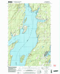
1990 Map of Vaughn
USGS Topo · Published 2003About this map
Case Inlet and its surrounding shorelines define the geography of this Pierce County coastal study, where the Key Peninsula meets the intricate waterways of South Puget Sound. Small residential communities and harbors are scattered throughout the landscape, from the protected waters of Vaughn Bay to the western edge of Pickering Passage. The area is characterized by its maritime orientation, featuring several boat ramps and coastal points like Dougall Point and Rocky Point.
Find a feature on this map
51 named features on this map. Tap any name to fly to it.
Don’t see what you’re looking for? This feature index may not catch every label — zoom into the map to look around manually.
Map Details
Editions of this 1990 Vaughn Map
This is the sole edition of this map. No revisions or reprints were ever made.
Other maps of this area

1937 · Olympia
USGS Topo · 1:62,500

1938 · Allyn
USGS Topo · 1:62,500

1940 · Anderson Island
USGS Topo · 1:62,500

1942 · Gig Harbor
USGS Topo · 1:62,500

1943 · Gig Harbor
USGS Topo · 1:62,500

1948 · Anderson Island
USGS Topo · 1:62,500

1948 · Anderson Island
USGS Topo · 1:24,000

1949 · Olympia
USGS Topo · 1:62,500

1953 · Burley
USGS Topo · 1:24,000

1953 · Sylvan
USGS Topo · 1:24,000