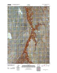
2011 Map of Venator Canyon
USGS Topo · Published 2011About this map
Alkali Valley defines this arid landscape of central Oregon, where the high desert terrain is punctuated by seasonal catchments and expansive basins. This 2011 survey illustrates a sparse infrastructure, primarily centered on the Alkali Lake State Airport and the corridor of Big Juniper Rd. The hydrography of the region is characterized by intermittent water bodies such as North Alkali Lake, Woods Lake, and Rehart Lake, which sit within the volcanic and sedimentary depressions of the Great Basin. The topographic relief is most pronounced at Venator Canyon, providing a look at the natural drainage patterns that have shaped this isolated environment. This map is particularly useful for understanding the modern footprint of remote state aviation facilities and the minimal but critical road network connecting these desert basins.
Find a feature on this map
7 named features on this map. Tap any name to fly to it.
Don’t see what you’re looking for? This feature index may not catch every label — zoom into the map to look around manually.
Map Details
Editions of this 2011 Venator Canyon Map
This is the sole edition of this map. No revisions or reprints were ever made.
Other maps of this area

1955 · Crescent
USGS Topo · 1:250,000

1955 · Klamath Falls
USGS Topo · 1:250,000

1955 · Burns
USGS Topo · 1:250,000

1955 · Adel
USGS Topo · 1:250,000

1957 · Adel
USGS Topo · 1:250,000

1957 · Crescent
USGS Topo · 1:250,000

1958 · Crescent
USGS Topo · 1:250,000

1958 · Klamath Falls
USGS Topo · 1:250,000

1958 · Burns
USGS Topo · 1:250,000

1958 · Adel
USGS Topo · 1:250,000