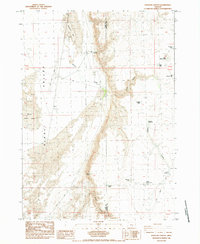
1984 Map of Venator Canyon
USGS Topo · Published 1984About this map
Hotchkiss Cow Camp sits near the northern boundary of this high desert landscape, representing the localized ranching infrastructure essential to the region in the early 1980s. The map illustrates a stark, arid environment where the border of Lake and Harney counties cuts through a series of ephemeral water bodies and vast sand dunes. Water management and natural catchment are central to the terrain, evidenced by named features like Venator Waterhole, Crossing Waterhole, and the seasonal Alkali Lake within the broad Alkali Valley.
Find a feature on this map
26 named features on this map. Tap any name to fly to it.
Don’t see what you’re looking for? This feature index may not catch every label — zoom into the map to look around manually.
Map Details
Editions of this 1984 Venator Canyon Map
This is the sole edition of this map. No revisions or reprints were ever made.
Other maps of this area

1955 · Crescent
USGS Topo · 1:250,000

1955 · Klamath Falls
USGS Topo · 1:250,000

1955 · Burns
USGS Topo · 1:250,000

1955 · Adel
USGS Topo · 1:250,000

1957 · Adel
USGS Topo · 1:250,000

1957 · Crescent
USGS Topo · 1:250,000

1958 · Crescent
USGS Topo · 1:250,000

1958 · Klamath Falls
USGS Topo · 1:250,000

1958 · Burns
USGS Topo · 1:250,000

1958 · Adel
USGS Topo · 1:250,000