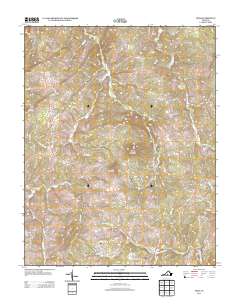
2013 Map of Vera
USGS Topo · Published 2013About this map
The Appomattox River winds through the southern portion of this Appomattox County landscape, anchoring a rural region defined by its narrow creeks and prominent peaks like Piney Mountain and Bald Mountain. The settlement of Oakville serves as a local hub in the west, while the community of Vera sits near the eastern edge, connected by a network of winding secondary roads.
Find a feature on this map
64 named features on this map. Tap any name to fly to it.
Don’t see what you’re looking for? This feature index may not catch every label — zoom into the map to look around manually.
Map Details
Editions of this 2013 Vera Map
This is the sole edition of this map. No revisions or reprints were ever made.
Other maps of this area

1892 · Buckingham
USGS Topo · 1:125,000

1892 · Appomattox
USGS Topo · 1:125,000

1947 · Roanoke
USGS Topo · 1:250,000

1958 · Appomattox
USGS Topo · 1:62,500

1958 · Pamplin City
USGS Topo · 1:62,500

1959 · Roanoke
USGS Topo · 1:250,000

1961 · Shipman
USGS Topo · 1:62,500

1961 · Buckingham
USGS Topo · 1:62,500

1963 · Roanoke
USGS Topo · 1:250,000
1968 · Concord
USGS Topo · 1:24,000