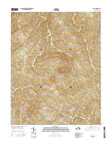
2016 Map of Vera
USGS Topo · Published 2016About this map
The Appomattox Court House National Historical Park occupies the southern reaches of this landscape, preserving the hallowed ground where the American Civil War effectively ended. The terrain is defined by the headwaters of the Appomattox River, which flows past landmarks like the Patterson-Hix Burial Ground and Babcock Cem. The topography is shaped by the presence of Piney Mtn and Bald Mtn, providing a backdrop to the small settlements of Oakville and Vera.
Find a feature on this map
64 named features on this map. Tap any name to fly to it.
Don’t see what you’re looking for? This feature index may not catch every label — zoom into the map to look around manually.
Map Details
Editions of this 2016 Vera Map
This is the sole edition of this map. No revisions or reprints were ever made.
Other maps of this area

1892 · Buckingham
USGS Topo · 1:125,000

1892 · Appomattox
USGS Topo · 1:125,000

1947 · Roanoke
USGS Topo · 1:250,000

1958 · Appomattox
USGS Topo · 1:62,500

1958 · Pamplin City
USGS Topo · 1:62,500

1959 · Roanoke
USGS Topo · 1:250,000

1961 · Shipman
USGS Topo · 1:62,500

1961 · Buckingham
USGS Topo · 1:62,500

1963 · Roanoke
USGS Topo · 1:250,000
1968 · Concord
USGS Topo · 1:24,000