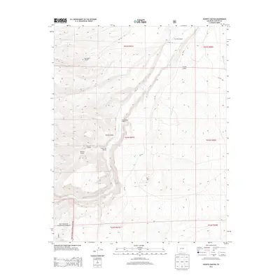
2013 Map of Vicente Canyon
USGS Topo · Published 2013About this map
Rio Grande National Forest dominates the southwestern portion of this Conejos County landscape, where the high-elevation terrain is defined by a complex network of seasonal drainages and named canyons. The namesake Vicente Canyon is flanked by several other landforms with family-named or descriptive Spanish origins, including Romero Canyon, Trujillo Canyon, and Ra Jadero Canyon. These labels reflect the cultural heritage of the southern San Luis Valley region.
Find a feature on this map
22 named features on this map. Tap any name to fly to it.
Don’t see what you’re looking for? This feature index may not catch every label — zoom into the map to look around manually.
Map Details
Editions of this 2013 Vicente Canyon Map
This is the sole edition of this map. No revisions or reprints were ever made.
Other maps of this area

1922 · Conejos
USGS Topo · 1:125,000

1945 · Durango
USGS Topo · 1:250,000

1953 · Durango
USGS Topo · 1:250,000

1954 · Durango
USGS Topo · 1:250,000

1961 · Durango
USGS Topo · 1:250,000

1963 · Durango
USGS Topo · 1:250,000

1966 · Durango
USGS Topo · 1:250,000
1967 · Osier
USGS Topo · 1:24,000
1967 · La Jara Canyon
USGS Topo · 1:24,000
1967 · Centro
USGS Topo · 1:24,000