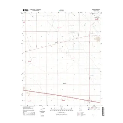
2014 Map of Vicksburg
USGS Topo · Published 2014About this map
Vicksburg and its surrounding desert settlements are situated within the wide expanse of the Ranegras Plain in this 2014 survey. The landscape is defined by its arid drainage patterns, including Bouse Wash, Calcite Wash, and Granite Wash, which are intersected by modern infrastructure. The Central Arizona Project Aqueduct cuts a distinct path through the northeastern corner, running parallel to the legacy of mining represented by the Bush Pit. The settlement patterns here follow established transit corridors like Us-60 and Vicksburg Rd, connecting small hubs such as Vicksburg Junction, Desert Wells, and New Hope. This layout reflects the area's continued reliance on highway access and the systematic management of water in the Arizona desert, where local roads like Panhandle Way and Eden Park Rd service a sparse but resilient residential and industrial footprint.
Find a feature on this map
32 named features on this map. Tap any name to fly to it.
Don’t see what you’re looking for? This feature index may not catch every label — zoom into the map to look around manually.
Map Details
Editions of this 2014 Vicksburg Map
This is the sole edition of this map. No revisions or reprints were ever made.
Other maps of this area

1942 · Vicksburg
USGS Topo · 1:250,000

1954 · Phoenix
USGS Topo · 1:250,000

1957 · Phoenix
USGS Topo · 1:250,000

1958 · Phoenix
USGS Topo · 1:250,000

1960 · Phoenix
USGS Topo · 1:250,000

1961 · Salome
USGS Topo · 1:62,500

1961 · Hope
USGS Topo · 1:62,500
1962 · Utting
USGS Topo · 1:62,500

1962 · Vicksburg
USGS Topo · 1:62,500

1969 · Phoenix
USGS Topo · 1:250,000