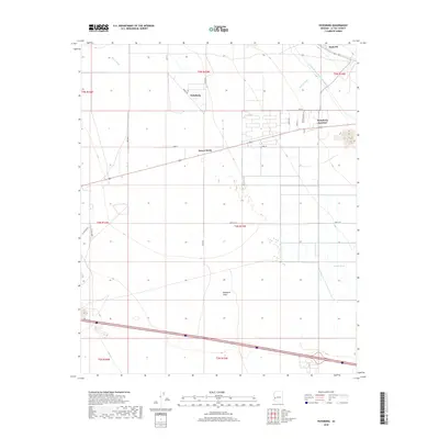
2018 Map of Vicksburg
USGS Topo · Published 2018About this map
Ranegras Plain dominates this arid landscape of western Arizona, where drainage patterns are defined by dry watercourses like Bouse Wash, Calcite Wash, and Granite Wash. The settlement of Vicksburg and nearby Vicksburg Junction represent the primary points of human habitation, situated along a transportation corridor that includes McVay Rd and several surveyed section lines. A notable feat of modern engineering, the Central Arizona Project Aqueduct, cuts across the northern portion of the quadrangle, bringing a stark industrial contrast to the surrounding desert flats. Small-scale developments such as Desert Wells and the Bush Pit extraction site are connected by a network of local roads including 63rd St and 60th St N, reflecting the sparse but functional infrastructure of La Paz County.
Find a feature on this map
28 named features on this map. Tap any name to fly to it.
Don’t see what you’re looking for? This feature index may not catch every label — zoom into the map to look around manually.
Map Details
Editions of this 2018 Vicksburg Map
This is the sole edition of this map. No revisions or reprints were ever made.
Other maps of this area

1942 · Vicksburg
USGS Topo · 1:250,000

1954 · Phoenix
USGS Topo · 1:250,000

1957 · Phoenix
USGS Topo · 1:250,000

1958 · Phoenix
USGS Topo · 1:250,000

1960 · Phoenix
USGS Topo · 1:250,000

1961 · Salome
USGS Topo · 1:62,500

1961 · Hope
USGS Topo · 1:62,500
1962 · Utting
USGS Topo · 1:62,500

1962 · Vicksburg
USGS Topo · 1:62,500

1969 · Phoenix
USGS Topo · 1:250,000