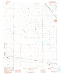
1990 Map of Vicksburg
USGS Topo · Published 1990About this map
The desert settlement of Vicksburg serves as a focal point for this 1990 survey of the Ranegras Plain. The landscape is defined by the intersection of traditional resource extraction and modern water management. Early mining history is evident in the southwest near the Bear Hills, where a Mine Shaft, Prospect Mine, and Open Pit Mine are recorded alongside a Check Dam.
Find a feature on this map
26 named features on this map. Tap any name to fly to it.
Don’t see what you’re looking for? This feature index may not catch every label — zoom into the map to look around manually.
Map Details
Editions of this 1990 Vicksburg Map
This is the sole edition of this map. No revisions or reprints were ever made.
Other maps of this area

1942 · Vicksburg
USGS Topo · 1:250,000

1954 · Phoenix
USGS Topo · 1:250,000

1957 · Phoenix
USGS Topo · 1:250,000

1958 · Phoenix
USGS Topo · 1:250,000

1960 · Phoenix
USGS Topo · 1:250,000

1961 · Salome
USGS Topo · 1:62,500

1961 · Hope
USGS Topo · 1:62,500
1962 · Utting
USGS Topo · 1:62,500

1962 · Vicksburg
USGS Topo · 1:62,500

1969 · Phoenix
USGS Topo · 1:250,000