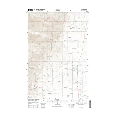
2014 Map of Victor
USGS Topo · Published 2014About this map
The settlement of Victor serves as the central hub of this Bitterroot Valley landscape, positioned along the corridor of Us-93 and the Bitterroot River. To the west, the terrain rises sharply into the Bitterroot National Forest, where steep drainages like McCalla Cr and Sweathouse Cr carve through the mountains. The valley floor is a patchwork of rural infrastructure and agricultural landmarks, including Indian Prairie and the low rise of Dineen Hill. Genealogical interest is centered on the Victor Cem and family-named routes such as McVey Rd and Whites Ln. The map also documents the complex hydrology of the river bottomlands, showing where N Channel Bear Cr and S Channel Bear Cr diverge near Poverty Flat. Small outposts at Bell Crossing and Victor Crossing mark historic transit points across the river, illustrating the community's long-standing connection to the water.
Find a feature on this map
94 named features on this map. Tap any name to fly to it.
Don’t see what you’re looking for? This feature index may not catch every label — zoom into the map to look around manually.
Map Details
Editions of this 2014 Victor Map
This is the sole edition of this map. No revisions or reprints were ever made.
Other maps of this area

1901 · Hamilton
USGS Topo · 1:125,000

1912 · Missoula
USGS Topo · 1:125,000

1956 · Hamilton
USGS Topo · 1:250,000

1959 · Hamilton
USGS Topo · 1:250,000

1960 · Hamilton
USGS Topo · 1:250,000

1964 · Hamilton
USGS Topo · 1:250,000

1964 · St. Joseph Peak
USGS Topo · 1:24,000
1966 · Printz Ridge
USGS Topo · 1:24,000
1966 · Gash Point
USGS Topo · 1:24,000
1967 · Saint Mary Peak
USGS Topo · 1:24,000