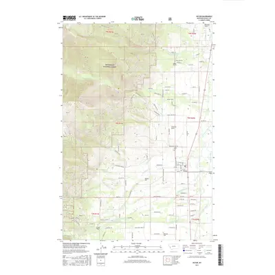
2017 Map of Victor
USGS Topo · Published 2017About this map
Victor serves as the primary settlement on this landscape, positioned along the eastern edge where the valley floor meets the Bitterroot River. This 2017 study illustrates the transition from the irrigated plains of Poverty Flat and Indian Prairie to the steep eastern slopes of the Bitterroot National Forest. The map captures a detailed network of rural residential expansion and agricultural infrastructure, particularly visible in the complex irrigation and drainage of Sweathouse Cr, Fred Burr Creek, and Little Smith Cr. Local history is embedded in the geography through names like Curlew Mine Rd and Curlew Orchard Rd, reflecting the area's legacy of extraction and orchard culture. Higher elevations are marked by landmarks like Dineen Hill and access points such as Saint Marys Peak Rd, while the Victor Cem provides a focal point for genealogical research at the town's edge.
Find a feature on this map
106 named features on this map. Tap any name to fly to it.
Don’t see what you’re looking for? This feature index may not catch every label — zoom into the map to look around manually.
Map Details
Editions of this 2017 Victor Map
This is the sole edition of this map. No revisions or reprints were ever made.
Other maps of this area

1901 · Hamilton
USGS Topo · 1:125,000

1912 · Missoula
USGS Topo · 1:125,000

1956 · Hamilton
USGS Topo · 1:250,000

1959 · Hamilton
USGS Topo · 1:250,000

1960 · Hamilton
USGS Topo · 1:250,000

1964 · Hamilton
USGS Topo · 1:250,000

1964 · St. Joseph Peak
USGS Topo · 1:24,000
1966 · Printz Ridge
USGS Topo · 1:24,000
1966 · Gash Point
USGS Topo · 1:24,000
1967 · Saint Mary Peak
USGS Topo · 1:24,000