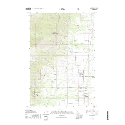
2020 Map of Victor
USGS Topo · Published 2020About this map
Saint Marys Peak Road climbs toward the high western ridges of the Bitterroot National Forest, where the prominent St Marys Peak dominates the skyline. This 2020 map documents the Bitterroot Valley floor, where the town of Victor sits near the Bitterroot River. The landscape here is defined by a clear transition from the steep, drainage-cut mountainsides of Big Creek and Sweathouse Creek to the irrigated agricultural flats and residential developments on the valley floor. Evidence of the area's development is seen in the grid of local roads like Curlew Orchard Rd and the presence of the Victor Cem. To the south, Poverty Flat and Dineen Hill mark the varied topography between the mountain canyons and the river, while landmarks like the Victor Bridge facilitate travel across the basin.
Find a feature on this map
122 named features on this map. Tap any name to fly to it.
Don’t see what you’re looking for? This feature index may not catch every label — zoom into the map to look around manually.
Map Details
Editions of this 2020 Victor Map
This is the sole edition of this map. No revisions or reprints were ever made.
Other maps of this area

1901 · Hamilton
USGS Topo · 1:125,000

1912 · Missoula
USGS Topo · 1:125,000

1956 · Hamilton
USGS Topo · 1:250,000

1959 · Hamilton
USGS Topo · 1:250,000

1960 · Hamilton
USGS Topo · 1:250,000

1964 · Hamilton
USGS Topo · 1:250,000

1964 · St. Joseph Peak
USGS Topo · 1:24,000
1966 · Printz Ridge
USGS Topo · 1:24,000
1966 · Gash Point
USGS Topo · 1:24,000
1967 · Saint Mary Peak
USGS Topo · 1:24,000