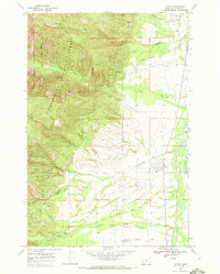
1967 Map of Victor
USGS Topo · Published 1972About this map
The Bitterroot River valley is the focal point of this 1967 survey, where the valley floor transitions sharply into the steep eastern slopes of the Bitterroot National Forest. The town of Victor serves as the primary hub, situated near the river and the historic Lewis and Clark Trail, which follows the base of the mountains. This area reflects a long history of natural resource extraction and rural education, evidenced by the Curlew Mine and the nearby Curlew Sch on the edge of the foothills.
Find a feature on this map
32 named features on this map. Tap any name to fly to it.
Don’t see what you’re looking for? This feature index may not catch every label — zoom into the map to look around manually.
Map Details
Editions of this 1967 Victor Map
This is the sole edition of this map. No revisions or reprints were ever made.
Other maps of this area

1901 · Hamilton
USGS Topo · 1:125,000

1912 · Missoula
USGS Topo · 1:125,000

1956 · Hamilton
USGS Topo · 1:250,000

1959 · Hamilton
USGS Topo · 1:250,000

1960 · Hamilton
USGS Topo · 1:250,000

1964 · Hamilton
USGS Topo · 1:250,000

1964 · St. Joseph Peak
USGS Topo · 1:24,000
1966 · Printz Ridge
USGS Topo · 1:24,000
1966 · Gash Point
USGS Topo · 1:24,000
1967 · Saint Mary Peak
USGS Topo · 1:24,000