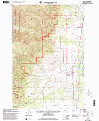
1998 Map of Victor
USGS Topo · Published 2002About this map
Bitterroot River waters define the valley floor here, where the settlement of Victor sits at the base of the dramatic Bitterroot Mountains. This 1998 revision, based on imagery and Forest Service updates, shows the transition from the irrigated ranching of Poverty Flat to the high-elevation reach of the Bitterroot National Forest. The map documents local industry and infrastructure, from the Bitterroot Branch railway line and multiple Gravel Pits to the Curlew Mines situated in the foothills. Cultural history is noted through the Historic Lewis and Clark National Trail following the river corridor, and local landmarks like the Curlew Sch and the town Cem. Numerous mountain drainages, including Sweathouse Creek and McCalla Creek, flow from the Selway-Bitterroot Wilderness into the valley, shaping the landscape west of the Guide Meridian.
Find a feature on this map
38 named features on this map. Tap any name to fly to it.
Don’t see what you’re looking for? This feature index may not catch every label — zoom into the map to look around manually.
Map Details
Editions of this 1998 Victor Map
This is the sole edition of this map. No revisions or reprints were ever made.
Other maps of this area

1901 · Hamilton
USGS Topo · 1:125,000

1912 · Missoula
USGS Topo · 1:125,000

1956 · Hamilton
USGS Topo · 1:250,000

1959 · Hamilton
USGS Topo · 1:250,000

1960 · Hamilton
USGS Topo · 1:250,000

1964 · Hamilton
USGS Topo · 1:250,000

1964 · St. Joseph Peak
USGS Topo · 1:24,000
1966 · Printz Ridge
USGS Topo · 1:24,000
1966 · Gash Point
USGS Topo · 1:24,000
1967 · Saint Mary Peak
USGS Topo · 1:24,000