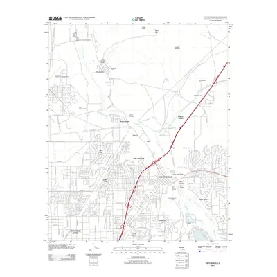
2012 Map of Victorville
USGS Topo · Published 2012About this map
The Mojave River carves a distinctive path through this High Desert landscape, defining the corridor between Quartzite Mountain and the growing suburban residential patterns of Victorville. This era reveals a complex interface of heavy infrastructure and desert settlement, where the BNSF Railway and the Southern California Logistics Airport dominate the northwestern plains. Near the northern reach, the settlement of Oro Grande sits by the river, marked by the Rodigues Cem and the deep incision of Oro Grande Canyon. The map records a transition from traditional desert ranching, such as the Kemper Campbell Ranch, to modern recreational and residential developments like Greentree East and the West Wind Golf Course. Significant geographic narrows along the river channel, including the Lower Narrows and Upper Narrows, dictate the historic placement of transportation routes through the valley.
Find a feature on this map
51 named features on this map. Tap any name to fly to it.
Don’t see what you’re looking for? This feature index may not catch every label — zoom into the map to look around manually.
Map Details
Editions of this 2012 Victorville Map
This is the sole edition of this map. No revisions or reprints were ever made.
Other maps of this area

1901 · Southern California Sheet No. 1
USGS Topo · 1:250,000

1902 · Deep Creek
USGS Topo · 1:62,500

1902 · Hesperia
USGS Topo · 1:62,500

1904 · Southern California Sheet No. 1
USGS Topo · 1:250,000

1932 · Barstow
USGS Topo · 1:125,000

1934 · Barstow
USGS Topo · 1:125,000

1942 · Hesperia
USGS Topo · 1:62,500

1953 · San Bernardino
USGS Topo · 1:250,000

1956 · San Bernardino
USGS Topo · 1:250,000
1956 · Baldy Mesa
USGS Topo · 1:24,000