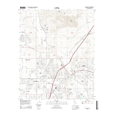
2015 Map of Victorville
USGS Topo · Published 2015About this map
The Mojave River carves a critical corridor through the High Desert in this 2015 study, anchoring the interconnected growth of Victorville, Adelanto, and Apple Valley. The landscape is a complex mix of industrial mining at the Victorville Quarry and the BNSF Railway transport spine that follows the river's path through the Lower Narrows. Notable landmarks include the Southern California Logistics Airport and the smaller Osborne Airport, alongside established residential sectors like Golden Mesa and Desert Knolls.
Find a feature on this map
50 named features on this map. Tap any name to fly to it.
Don’t see what you’re looking for? This feature index may not catch every label — zoom into the map to look around manually.
Map Details
Editions of this 2015 Victorville Map
This is the sole edition of this map. No revisions or reprints were ever made.
Other maps of this area

1901 · Southern California Sheet No. 1
USGS Topo · 1:250,000

1902 · Deep Creek
USGS Topo · 1:62,500

1902 · Hesperia
USGS Topo · 1:62,500

1904 · Southern California Sheet No. 1
USGS Topo · 1:250,000

1932 · Barstow
USGS Topo · 1:125,000

1934 · Barstow
USGS Topo · 1:125,000

1942 · Hesperia
USGS Topo · 1:62,500

1953 · San Bernardino
USGS Topo · 1:250,000

1956 · San Bernardino
USGS Topo · 1:250,000
1956 · Baldy Mesa
USGS Topo · 1:24,000