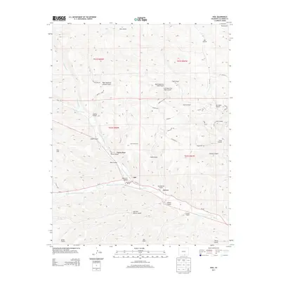
2013 Map of Vigil
USGS Topo · Published 2013About this map
The Purgatoire River drainage system dominates this southern Colorado landscape, where the confluence of the N Fork Purgatoire River and Middle Fork Purgatoire River shapes the local topography. Small settlements and historic ranches like Vigil, Zamara, and Parras Plaza are concentrated along the river corridor, linked by Co-12. The surrounding terrain is defined by a dense network of named canyons, including Santistevan Canyon and Apache Canyon, indicating a complex drainage pattern that feeds into the Picketwire Valley. To the north and west, significant elevations rise toward the Pete Hills and the Ute Hills. This area includes the Spanish Peaks Trl and various mountain routes like Timber Valley Dr, highlighting the region's intersection of traditional river-bottom ranching and modern recreational access.
Find a feature on this map
51 named features on this map. Tap any name to fly to it.
Don’t see what you’re looking for? This feature index may not catch every label — zoom into the map to look around manually.
Map Details
Editions of this 2013 Vigil Map
This is the sole edition of this map. No revisions or reprints were ever made.
Other maps of this area

1891 · Spanish Peaks
USGS Topo · 1:125,000

1893 · Spanish Peaks
USGS Topo · 1:125,000

1895 · Spanish Peaks
USGS Topo · 1:125,000

1897 · Spanish Peaks
USGS Topo · 1:125,000

1900 · Spanish Peaks
USGS Topo · 1:125,000

1954 · Trinidad
USGS Topo · 1:250,000

1955 · Trinidad
USGS Topo · 1:250,000

1958 · Trinidad
USGS Topo · 1:250,000

1959 · Trinidad
USGS Topo · 1:250,000
1967 · Cucharas Pass
USGS Topo · 1:24,000