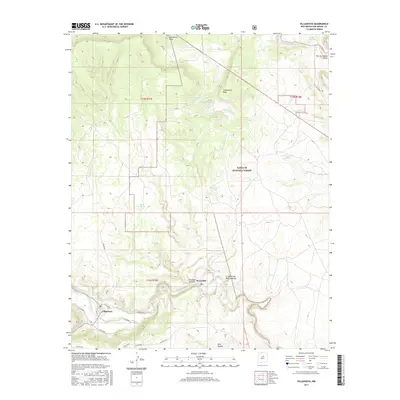
2017 Map of Villanueva
USGS Topo · Published 2017About this map
Villanueva sits along a bend of the Pecos River in this detailed look at a high-elevation New Mexico landscape. The area is defined by sharp elevation changes and traditional water management, featuring a network of livestock tanks such as Cattleguard Tank and Head Quarters Tank, alongside natural features like Lagunita Springs. The terrain rises toward the north to the prominent Starvation Peak and the expansive Sombodoro Mesa, while the southern portion of the map is carved by deep drainage systems like El Cañon de Pena and El Cañon del Palo Amarillo. Much of the central and eastern territory is protected as part of the Santa Fe National Forest. This modern survey documents the complex local road network including New Rd and several county routes that provide access to the various cañons and mesas that characterize this San Miguel County geography.
Find a feature on this map
33 named features on this map. Tap any name to fly to it.
Don’t see what you’re looking for? This feature index may not catch every label — zoom into the map to look around manually.
Map Details
Editions of this 2017 Villanueva Map
This is the sole edition of this map. No revisions or reprints were ever made.
Other maps of this area

1890 · Bernal
USGS Topo · 1:125,000

1891 · Bernal
USGS Topo · 1:125,000

1894 · Bernal
USGS Topo · 1:125,000

1954 · Santa Fe
USGS Topo · 1:250,000

1958 · Santa Fe
USGS Topo · 1:250,000

1960 · Villanueva
USGS Topo · 1:62,500

1960 · Apache Springs
USGS Topo · 1:62,500
1963 · Anton Chico
USGS Topo · 1:24,000

1963 · Aurora
USGS Topo · 1:24,000
1963 · San Juan
USGS Topo · 1:24,000