1919 Map of Vineland
USGS Topo · Published 1921About this map
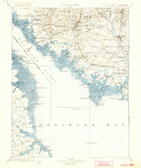
The Maurice River and Cohansey River define the maritime character of this Southern New Jersey coastal region at the end of the First World War. Coastal settlements like Bivalve and Port Norris serve as vital hubs for the local oyster industry, while the inland centers of Vineland and Millville show the structured grid patterns of early planned communities. This survey, updated by the Corps of Engineers, U.S. Army, highlights the intricate network of water-based infrastructure, including Canings Wharf and Tindell Ldg., which connected the agricultural interior to the Delaware Bay.
Find a feature on this map
163 named features on this map. Tap any name to fly to it.
Don’t see what you’re looking for? This feature index may not catch every label — zoom into the map to look around manually.
Map Details
Editions of this 1919 Vineland Map
This is the sole edition of this map. No revisions or reprints were ever made.