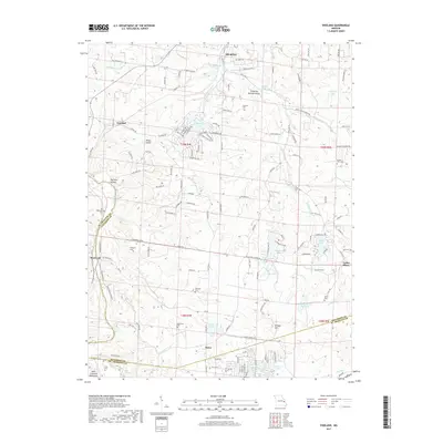
2017 Map of Vineland
USGS Topo · Published 2017About this map
Valles Mines and the surrounding township at the southern edge of Jefferson County reveal a landscape defined by its mining history and rugged drainages. The topography is anchored by the northern reaches of the Saint Francois Mountains, where the Big River carves through the southwestern corner. Numerous small family and community burial grounds, such as Old Blackwell Cem, Vineyard Cem, and Moontown Cem, are scattered across the hills, providing vital markers for genealogical research. The settlement pattern follows old mineral leads and creek beds, with small communities like Vineland, Melzo, and Blackwell linked by a network of rural routes like State Hwy V and McMullin School Rd. Along Joachim Creek and its tributaries, dozens of small lakes and reservoirs, including Sunrise Lake and Valle Lake, suggest the conversion of former industrial or agricultural lands into residential and recreational spaces.
Find a feature on this map
147 named features on this map. Tap any name to fly to it.
Don’t see what you’re looking for? This feature index may not catch every label — zoom into the map to look around manually.
Map Details
Editions of this 2017 Vineland Map
This is the sole edition of this map. No revisions or reprints were ever made.
Other maps of this area

1901 · De Soto
USGS Topo · 1:125,000

1904 · Farmington
USGS Topo · 1:62,500

1905 · Bonneterre
USGS Topo · 1:62,500

1906 · Farmington
USGS Topo · 1:62,500

1915 · Crystal City
USGS Topo · 1:62,500

1930 · De Soto NE
USGS Topo · 1:24,000

1931 · De Soto SE
USGS Topo · 1:24,000

1937 · Fletcher
USGS Topo · 1:24,000

1937 · Tiff
USGS Topo · 1:24,000

1938 · Fletcher
USGS Topo · 1:24,000