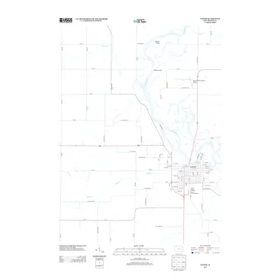
2013 Map of Vinton
USGS Topo · Published 2013About this map
The Cedar River winds through the heart of this landscape, anchoring the settlement of Vinton. The river’s natural evolution is evident north of the city at Barnets Island and the adjacent Barnets Cutoff, highlighting the shifting hydrology of this part of Benton County. Several significant community landmarks define the southern and northern outskirts of the town. To the south, the Benton County Fairgrounds and the Benton County Speedway represent central hubs for local assembly and recreation. In the northeast, the Vinton Veterans Memorial Airpark serves the region’s aviation needs. The surrounding terrain is drained by a network of tributaries including Hinkle Cr, Mud Cr, and Pratt Cr, which carve through a grid of rural avenues and streets that radiate from the urban center.
Find a feature on this map
85 named features on this map. Tap any name to fly to it.
Don’t see what you’re looking for? This feature index may not catch every label — zoom into the map to look around manually.
Map Details
Editions of this 2013 Vinton Map
This is the sole edition of this map. No revisions or reprints were ever made.
Other maps of this area

1888 · Shellsburg
USGS Topo · 1:62,500

1889 · Shellsburg
USGS Topo · 1:62,500

1899 · Shellsburg
USGS Topo · 1:62,500

1903 · Winthrop
USGS Topo · 1:125,000

1954 · Waterloo
USGS Topo · 1:250,000

1955 · Waterloo
USGS Topo · 1:250,000

1959 · Dubuque
USGS Topo · 1:250,000

1961 · Dubuque
USGS Topo · 1:250,000

1962 · Dubuque
USGS Topo · 1:250,000
1968 · Center Point SW
USGS Topo · 1:24,000