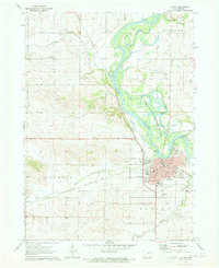
1971 Map of Vinton
USGS Topo · Published 1973About this map
The Cedar River creates a dynamic corridor through this portion of Benton County, shaping the growth and recreation patterns of Vinton. On the western bank, the Chicago Rock Island and Pacific railroad parallels the water, serving the town's industrial needs and nearby Quarry sites. The community’s civic and social infrastructure is well-defined, featuring prominent institutions such as the Iowa Braille & Sightsaving Sch, Gay Hospital, and multiple local schools including Lincoln High Sch and Washington High Sch. North of the city, the Dudgeon Lake State Wildlife Management Area covers a complex network of wetlands and sloughs, while Barnets Island and Barnets Cutoff illustrate the shifting nature of the river channel. For genealogists, the map is particularly useful for locating cemeteries such as Evergreen Cem, Maplewood Cem, and the more remote Greenwalt Cem.
Find a feature on this map
41 named features on this map. Tap any name to fly to it.
Don’t see what you’re looking for? This feature index may not catch every label — zoom into the map to look around manually.
Map Details
Editions of this 1971 Vinton Map
This is the sole edition of this map. No revisions or reprints were ever made.
Other maps of this area

1888 · Shellsburg
USGS Topo · 1:62,500

1889 · Shellsburg
USGS Topo · 1:62,500

1899 · Shellsburg
USGS Topo · 1:62,500

1903 · Winthrop
USGS Topo · 1:125,000

1954 · Waterloo
USGS Topo · 1:250,000

1955 · Waterloo
USGS Topo · 1:250,000

1959 · Dubuque
USGS Topo · 1:250,000

1961 · Dubuque
USGS Topo · 1:250,000

1962 · Dubuque
USGS Topo · 1:250,000
1968 · Center Point SW
USGS Topo · 1:24,000