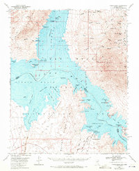
1970 Map of Virgin Basin
USGS Topo · Published 1972About this map
The Lake Mead reservoir dominates this landscape where the Virgin River and Colorado River converge across the Nevada-Arizona border. This survey details a transition in the desert landscape as rising waters filled the basin, creating distinct features like Middle Point Islands and Pool Islands. The topography includes the complex underwater contours of Bonelli Bay and Temple Basin, alongside dramatic geological formations such as The Temple, Napoleons Tomb, and The Campanile. Recreational development is evident at the Temple Bar Marina, which features a boat anchorage and ramp, a campground, and a nearby landing field. Local history is captured through markers like the Lakeside Mine and a solitary grave near Gann Spring, reflecting the sparse human presence in the Black Mountains and White Hills.
Find a feature on this map
68 named features on this map. Tap any name to fly to it.
Don’t see what you’re looking for? This feature index may not catch every label — zoom into the map to look around manually.
Map Details
Editions of this 1970 Virgin Basin Map
2 editions found
Other maps of this area

1886 · Camp Mohave
USGS Topo · 1:250,000

1886 · Saint Thomas
USGS Topo · 1:250,000

1892 · Camp Mohave
USGS Topo · 1:250,000

1893 · Saint Thomas
USGS Topo · 1:250,000

1926 · Nelson
USGS Topo · 1:96,000

1926 · Bonelli
USGS Topo · 1:96,000

1926 · Boulder Canyon
USGS Topo · 1:96,000

1942 · Camp Mohave
USGS Topo · 1:250,000

1947 · Kingman
USGS Topo · 1:250,000

1948 · Kingman
USGS Topo · 1:250,000