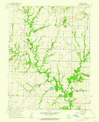
1961 Map of Virginia
USGS Topo · Published 1962About this map
Virginia serves as the primary settlement in this section of Bates County, anchoring a landscape defined by the drainage of Miami Creek and its various tributaries like Bones Branch. The area is characterized by a strong civic infrastructure of the early 1960s, evidenced by a high density of rural meeting places including Pleasant Valley Community Hall, Mount Vernon Community Hall, and Wilcox Community Hall. Genealogists will find significant value in the distribution of family-named landmarks and burial grounds, such as Howell Cem and Park Cem, alongside the Virginia Cem near the town center. The presence of Butler Lake and a Pumping Station suggests a managed water system for the surrounding agricultural townships of Elkhart, Charlotte, and Mount Pleasant. This survey captures the transition of rural life before further consolidation, preserving the locations of the Baptist Ch and the Tygard Sch.
Find a feature on this map
22 named features on this map. Tap any name to fly to it.
Don’t see what you’re looking for? This feature index may not catch every label — zoom into the map to look around manually.
Map Details
Editions of this 1961 Virginia Map
This is the sole edition of this map. No revisions or reprints were ever made.
Other maps of this area

1887 · Butler
USGS Topo · 1:125,000

1887 · Mound City
USGS Topo · 1:125,000

1893 · Mound City
USGS Topo · 1:125,000

1894 · Butler
USGS Topo · 1:125,000

1937 · New Home
USGS Topo · 1:24,000

1938 · Worland
USGS Topo · 1:24,000

1940 · Worland
USGS Topo · 1:24,000

1947 · Lawrence
USGS Topo · 1:250,000

1950 · Lawrence
USGS Topo · 1:250,000

1956 · Lawrence
USGS Topo · 1:250,000