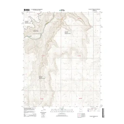
2014 Map of Vulcans Throne SW
USGS Topo · Published 2014About this map
The Colorado River carves a deep path through northwestern Arizona, marking a dramatic boundary between Mohave and Coconino counties. This 2014 survey captures a section where the river transitions from the protected reaches of Grand Canyon National Park into the Lake Mead National Recreation Area. The landscape is defined by its severe verticality, with named drainages like Hundred and Ninetytwo Mile Canyon and Boulder Wash incising the plateau. The placement of Big Spring near the southern edge of the sheet indicates one of the rare reliable water sources in this arid environment. The map provides an exceptionally clear look at the complex contouring of features such as Hells Hollow, illustrating the intricate geological layering characteristic of the canyon's edge before the terrain levels out toward the high desert plains.
Find a feature on this map
10 named features on this map. Tap any name to fly to it.
Don’t see what you’re looking for? This feature index may not catch every label — zoom into the map to look around manually.
Map Details
Editions of this 2014 Vulcans Throne SW Map
This is the sole edition of this map. No revisions or reprints were ever made.
Other maps of this area

1886 · Diamond Creek
USGS Topo · 1:250,000

1886 · Mt. Trumbull
USGS Topo · 1:250,000

1892 · Diamond Creek
USGS Topo · 1:250,000

1892 · Mt. Trumbull
USGS Topo · 1:250,000

1948 · Williams
USGS Topo · 1:250,000

1953 · Grand Canyon
USGS Topo · 1:250,000

1954 · Williams
USGS Topo · 1:250,000

1956 · Williams
USGS Topo · 1:250,000

1957 · Grand Canyon
USGS Topo · 1:250,000

1958 · Grand Canyon
USGS Topo · 1:250,000