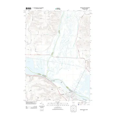
2013 Map of Wabasha North
USGS Topo · Published 2013About this map
Wabasha stands as a focal point along the western bank of the Mississippi River in this 2013 survey, where the confluence with the Chippewa River creates a complex network of waterways and islands. The terrain is defined by dramatic elevation changes, notably Wabasha Hill and several deep ravines such as Schmidt Coulee and Ryan Coulee. To the north, the historic riverfront community of Reads Landing remains a significant marker of early river navigation, situated near the southern tip of Lake Pepin. The eastern side of the river in Wisconsin is a vast wetland of braided channels including Buffalo Slough, Shively Slough, and Dark Slough. Local history is preserved at the Riverview Cem and Saint Felix Cem, while the modern river economy is visible at the Mississippi Parkside Marina. This map illustrates the intersection of major transportation routes like Us-61 and Great River Rd with the enduring natural hydrology of the Upper Mississippi valley.
Find a feature on this map
78 named features on this map. Tap any name to fly to it.
Don’t see what you’re looking for? This feature index may not catch every label — zoom into the map to look around manually.
Map Details
Editions of this 2013 Wabasha North Map
This is the sole edition of this map. No revisions or reprints were ever made.
Other maps of this area

1929 · Durand
USGS Topo · 1:62,500

1932 · Wabasha
USGS Topo · 1:62,500

1932 · Durand
USGS Topo · 1:62,500

1932 · Alma
USGS Topo · 1:62,500

1935 · Arkansaw
USGS Topo · 1:48,000

1941 · Arkansaw
USGS Topo · 1:62,500

1942 · Arkansaw
USGS Topo · 1:62,500

1950 · Alma
USGS Topo · 1:62,500

1951 · Wabasha
USGS Topo · 1:62,500

1953 · Saint Paul
USGS Topo · 1:250,000