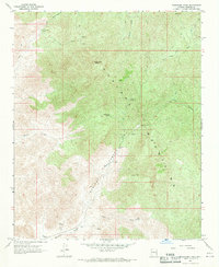
1967 Map of Wabayuma Peak
USGS Topo · Published 1980About this map
Wabayuma Peak anchors this high-desert terrain within the Hualapai Mountains during the late 1960s. The landscape is defined by its mining heritage and water-dependent ranching, as evidenced by the remote Boriana Mines tucked into the steep walls of Boriana Canyon and the Antler Mine further south. These operations relied on a network of isolated water sources like Boriana Well, Cottonwood Spring, and Bee Springs to sustain life and industry in the arid Mohave highlands.
Find a feature on this map
28 named features on this map. Tap any name to fly to it.
Don’t see what you’re looking for? This feature index may not catch every label — zoom into the map to look around manually.
Map Details
Editions of this 1967 Wabayuma Peak Map
2 editions found
Other maps of this area

1886 · Diamond Creek
USGS Topo · 1:250,000

1886 · Camp Mohave
USGS Topo · 1:250,000

1892 · Diamond Creek
USGS Topo · 1:250,000

1892 · Camp Mohave
USGS Topo · 1:250,000

1923 · Signal
USGS Topo · 1:250,000

1927 · Yucca
USGS Topo · 1:62,500

1929 · Yucca
USGS Topo · 1:62,500

1942 · Camp Mohave
USGS Topo · 1:250,000

1942 · Signal
USGS Topo · 1:250,000

1947 · Kingman
USGS Topo · 1:250,000