
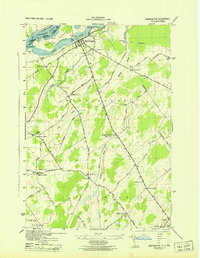
1942 Map of Waddington
USGS Topo · Published 1957About this map
Waddington sits at the northern edge of this territory, where the St Lawrence River splits around Ogden Island and the Little River. The international border with Canada is clearly marked in the river channel, reflecting a mid-century landscape before major Seaway transformations. Inland, the rural character of St. Lawrence County is defined by a dense network of country roads like Lower Irish Settlement Road and Hardscrabble Road, connecting a series of named crossroads including Henrys Corners and Wagners Corners.
Find a feature on this map
54 named features on this map. Tap any name to fly to it.
Don’t see what you’re looking for? This feature index may not catch every label — zoom into the map to look around manually.
Map Details
Editions of this 1942 Waddington Map
This is the sole edition of this map. No revisions or reprints were ever made.
Other maps of this area

1904 · Lisbon
USGS Topo · 1:48,000

1904 · Ogdensburg
USGS Topo · 1:62,500

1905 · Waddington
USGS Topo · 1:62,500

1905 · Ogdensburg
USGS Topo · 1:62,500

1906 · Red Mills
USGS Topo · 1:62,500

1910 · Canton
USGS Topo · 1:62,500

1911 · Canton
USGS Topo · 1:62,500

1942 · Chase Mills
USGS Topo · 1:24,000

1942 · Murphy Island
USGS Topo · 1:24,000
1943 · Waddington
USGS Topo · 1:31,680