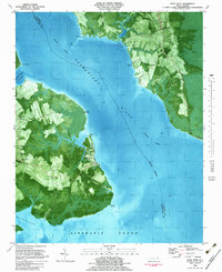
1982 Map of Wade Point
USGS Topo · Published 1983About this map
The Pasquotank River serves as the central geographic divide in this 1982 orthophotomap, separating Camden and Pasquotank counties as it empties into the Albemarle Sound. This specialized map combines traditional topographic contouring with aerial photography, revealing the intricate land-use patterns of the early 1980s. Along the eastern shore, the settlement of Old Trap is surrounded by a network of drainage features like Beaverdam Swamp and Goose Creek, while the western banks are defined by the winding course of Newbegun Creek and Flatty Creek.
Find a feature on this map
29 named features on this map. Tap any name to fly to it.
Don’t see what you’re looking for? This feature index may not catch every label — zoom into the map to look around manually.
Map Details
Editions of this 1982 Wade Point Map
2 editions found
Other maps of this area

1940 · Barco
USGS Topo · 1:62,500

1940 · Powells Point
USGS Topo · 1:62,500

1940 · Wade Point
USGS Topo · 1:62,500

1943 · Wade Point
USGS Topo · 1:62,500

1946 · Eastville
USGS Topo · 1:250,000

1946 · Currituck Sound
USGS Topo · 1:250,000

1948 · Wade Point
USGS Topo · 1:62,500

1948 · Elizabeth City
USGS Topo · 1:62,500

1953 · Norfolk
USGS Topo · 1:250,000

1961 · Eastville
USGS Topo · 1:250,000