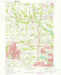
1969 Map of Wadsworth
USGS Topo · Published 1979About this map
Wadsworth and Barberton dominate the southern half of this landscape, showing the post-war industrial and residential expansion at the boundary of Medina and Summit counties. The area is characterized by a dense network of local institutions, including Woodlawn Cemetery, Sacred Heart Ch, and numerous neighborhood schools like Isham Sch and Valley View Sch. This 1969 survey, updated with 1977 purple-tinted photorevisions, captures the intersection of major transportation corridors such as the Ohio Turnpike and the Conrail line. Between the urban centers, the terrain transitions into a patchwork of rural holdings and water bodies like Barberton Reservoir, Lake Dorothy, and Loyal Oak Lake. Smaller crossroads settlements like Western Star, Sharon Center, and Clark Corners remain distinct, marking the traditional centers of the surrounding townships before suburban infill bridged the gaps between the larger cities.
Find a feature on this map
58 named features on this map. Tap any name to fly to it.
Don’t see what you’re looking for? This feature index may not catch every label — zoom into the map to look around manually.
Map Details
Editions of this 1969 Wadsworth Map
2 editions found
Other maps of this area

1901 · Massillon
USGS Topo · 1:62,500

1901 · Wooster
USGS Topo · 1:62,500

1903 · Massillon
USGS Topo · 1:62,500

1903 · Wooster
USGS Topo · 1:62,500

1903 · Akron
USGS Topo · 1:62,500

1904 · Medina
USGS Topo · 1:62,500

1905 · Akron
USGS Topo · 1:62,500

1906 · Medina
USGS Topo · 1:62,500

1950 · Cleveland
USGS Topo · 1:250,000

1951 · Canton
USGS Topo · 1:250,000