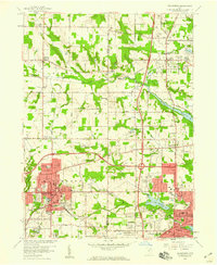
1958 Map of Wadsworth
USGS Topo · Published 1959About this map
Wadsworth and the western edge of Barberton dominate this late-1950s landscape, reflecting a period of post-war suburban development and established industrial centers. The urban core of Wadsworth is highly detailed, featuring civic landmarks like the City Hall Library PO, Woodlawn Cemetery, and several neighborhood schools including Lincoln Sch and Franklin Sch. To the east, the terrain shifts into the water-rich geography of Barberton Reservoir and Lake Dorothy, which are surrounded by smaller community clusters like Loyal Oak and Norton Center.
Find a feature on this map
65 named features on this map. Tap any name to fly to it.
Don’t see what you’re looking for? This feature index may not catch every label — zoom into the map to look around manually.
Map Details
Editions of this 1958 Wadsworth Map
This is the sole edition of this map. No revisions or reprints were ever made.
Other maps of this area

1901 · Massillon
USGS Topo · 1:62,500

1901 · Wooster
USGS Topo · 1:62,500

1903 · Massillon
USGS Topo · 1:62,500

1903 · Wooster
USGS Topo · 1:62,500

1903 · Akron
USGS Topo · 1:62,500

1904 · Medina
USGS Topo · 1:62,500

1905 · Akron
USGS Topo · 1:62,500

1906 · Medina
USGS Topo · 1:62,500

1950 · Cleveland
USGS Topo · 1:250,000

1951 · Canton
USGS Topo · 1:250,000