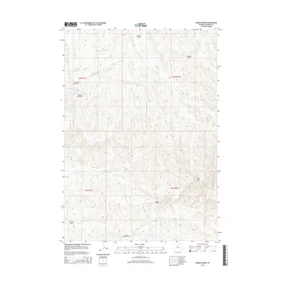
2015 Map of Wagon Prong
USGS Topo · Published 2015About this map
Wagon Prong and its surrounding drainage system characterize this high-desert region of Washakie County, Wyoming. The landscape is defined by a sophisticated network of water management features, including Old Quaker Reservoir, Davis Reservoir Number 2, and Hayes Reservoir, which sit amid a series of named coulees and ephemeral streams. These reservoirs and draws represent the vital infrastructure required for ranching and land use in an arid environment where surface water is scarce.
Find a feature on this map
28 named features on this map. Tap any name to fly to it.
Don’t see what you’re looking for? This feature index may not catch every label — zoom into the map to look around manually.
Map Details
Editions of this 2015 Wagon Prong Map
This is the sole edition of this map. No revisions or reprints were ever made.
Other maps of this area

1955 · Arminto
USGS Topo · 1:250,000

1958 · Arminto
USGS Topo · 1:250,000

1960 · Packsaddle Creek
USGS Topo · 1:24,000

1962 · Arminto
USGS Topo · 1:250,000

1966 · Deadline Draw
USGS Topo · 1:24,000

1966 · Sand Point
USGS Topo · 1:24,000

1966 · Cabin Fork
USGS Topo · 1:24,000

1966 · Wagon Prong
USGS Topo · 1:24,000

1966 · Bader Draw
USGS Topo · 1:24,000
1966 · Henry Draw
USGS Topo · 1:24,000