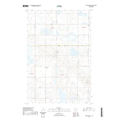
2020 Map of Wagon Wheel Hill
USGS Topo · Published 2020About this map
Wagon Wheel Hill stands as a prominent topographical feature in this northern Great Plains landscape, situated along the county line where Wells Co meets Kidder Co. The area is characterized by a high density of small wetlands and prairie potholes, typical of the glacial till plains in this region. Human settlement is sparse, marked primarily by a grid of rural sections roads including 38th Ave SE and 47th St SE. A notable historical site is the Methodist Episcopal Cem, which serves as a quiet reminder of early pioneer religious communities in the township of t144n r71w. Transportation and infrastructure are represented by the small Buchmiller Airport in the northeast corner and Co Hwy 71, which winds through the eastern portion of the terrain.
Find a feature on this map
22 named features on this map. Tap any name to fly to it.
Don’t see what you’re looking for? This feature index may not catch every label — zoom into the map to look around manually.
Map Details
Editions of this 2020 Wagon Wheel Hill Map
This is the sole edition of this map. No revisions or reprints were ever made.
Other maps of this area

1951 · Bowdon
USGS Topo · 1:24,000

1951 · Heaton
USGS Topo · 1:24,000

1952 · New Rockford
USGS Topo · 1:250,000

1956 · New Rockford
USGS Topo · 1:250,000

1971 · New Rockford
USGS Topo · 1:250,000

1972 · Lake Williams
USGS Topo · 1:24,000

1972 · Robinson
USGS Topo · 1:24,000

1972 · Des Moines Lake
USGS Topo · 1:24,000

1978 · Wagon Wheel Hill
USGS Topo · 1:24,000
1978 · Bowdon SE
USGS Topo · 1:24,000