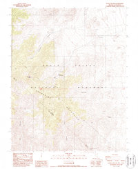
1987 Map of Wahguyhe Peak
USGS Topo · Published 1987About this map
Wahguyhe Peak towers over the high ridges of the Grapevine Mountains along the border of Nevada and California in the late 1980s. This desert landscape within the Death Valley National Monument reveals a sparse history of human enterprise, characterized by isolated water sources and early ranching attempts. The Strozzi Ranch and the Mexican Camp (Site) represent these small footholds in an arid environment, while a Prospect to the northwest points to the mineral interests common in Nye County. Deep drainages such as Phinney Canyon, Titus Canyon, and Fall Canyon cut through the terrain, leading toward the lower elevations of the valley floor. Several vital water points are identified, including Brier Spring, Alkali Spring, and McDonald Spring, which were essential for survival in this high-desert territory.
Find a feature on this map
18 named features on this map. Tap any name to fly to it.
Don’t see what you’re looking for? This feature index may not catch every label — zoom into the map to look around manually.
Map Details
Editions of this 1987 Wahguyhe Peak Map
This is the sole edition of this map. No revisions or reprints were ever made.
Other maps of this area

1908 · Kawich
USGS Topo · 1:250,000

1908 · Lida
USGS Topo · 1:250,000

1908 · Furnace Creek
USGS Topo · 1:250,000

1908 · Ballarat
USGS Topo · 1:250,000

1910 · Furnace Creek
USGS Topo · 1:250,000

1913 · Lida
USGS Topo · 1:250,000

1913 · Ballarat
USGS Topo · 1:250,000

1942 · Tolicha Peak
USGS Topo · 1:125,000

1942 · Bullfrog
USGS Topo · 1:125,000

1948 · Death Valley
USGS Topo · 1:250,000