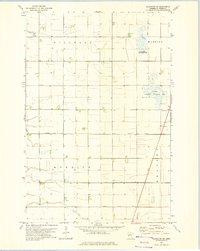
1973 Map of Wahpeton NE
USGS Topo · Published 1975About this map
Agricultural life in Wilkin County is defined by an extensive network of drainage infrastructure, such as County Ditch No 15 and County Ditch No 6-A. These man-made channels crisscross the townships of Mitchell, Manston, Nordick, and Meadows, revealing the effort required to manage the prairie landscape for cultivation. Near the northwestern corner, a small cluster of community life is visible around the Mitchell Cem and a local Townhall, while a Gravel Pit indicates local industrial activity. The map also highlights significant conservation efforts through the Manston State Wildlife Management Area and the National Waterfowl Production Area, which preserve wetlands amidst the surrounding farmstead parcels. Central to the spiritual life of the area is Christ Ch, situated just west of the Manston marshes. The small settlement of Meadows appears in the eastern section, marked by a Radio Tower and nearby survey benchmarks.
Find a feature on this map
19 named features on this map. Tap any name to fly to it.
Don’t see what you’re looking for? This feature index may not catch every label — zoom into the map to look around manually.
Map Details
Editions of this 1973 Wahpeton NE Map
This is the sole edition of this map. No revisions or reprints were ever made.
Other maps of this area

1895 · Fargo
USGS Topo · 1:125,000

1897 · Fargo
USGS Topo · 1:125,000

1904 · Wahpeton
USGS Topo · 1:125,000

1919 · Rothsay
USGS Topo · 1:62,500

1919 · Barnesville
USGS Topo · 1:62,500

1951 · Rothsay
USGS Topo · 1:62,500

1952 · Barnesville
USGS Topo · 1:62,500

1953 · Fargo
USGS Topo · 1:250,000

1956 · Fargo
USGS Topo · 1:250,000

1964 · Dwight
USGS Topo · 1:24,000