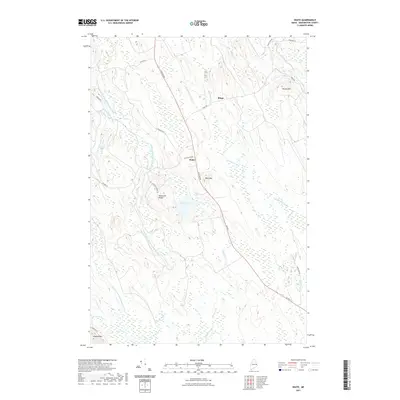
2021 Map of Waite
USGS Topo · Published 2021About this map
Waite serves as a central junction in this corner of Washington County, where Houlton Rd and US Rte 1 trace a corridor through a landscape defined by extensive wetlands and glacial topography. The settlement of Bingo and landmarks like Democrat Ridge punctuate the upland reaches between the many waterways that feed the region’s drainage. This modern 2021 survey illustrates a classic Maine interior pattern of remote ridge roads and low-lying marshes, particularly around the East Branch Big Musquash Stream and West Branch Big Musquash Stream. The presence of Old Mill Rd near the town center points to a legacy of timber and water-powered industry, while the surrounding peaks, including Neal Mtn and McLain Mtn, provide the topographical boundaries for local brooks such as Huntley Brook and Tomah Stream.
Find a feature on this map
32 named features on this map. Tap any name to fly to it.
Don’t see what you’re looking for? This feature index may not catch every label — zoom into the map to look around manually.
Map Details
Editions of this 2021 Waite Map
This is the sole edition of this map. No revisions or reprints were ever made.
Other maps of this area

1940 · Waite
USGS Topo · 1:62,500

1941 · Scraggly Lake
USGS Topo · 1:62,500

1941 · Big Lake
USGS Topo · 1:62,500

1941 · Wabassus Lake
USGS Topo · 1:62,500

1942 · Waite
USGS Topo · 1:62,500

1943 · Big Lake
USGS Topo · 1:62,500

1943 · Wabassus Lake
USGS Topo · 1:62,500

1944 · Scraggly Lake
USGS Topo · 1:62,500

1952 · Big Lake
USGS Topo · 1:50,000

1953 · Wabassus Lake
USGS Topo · 1:62,500