
1942 Map of Waite
USGS Topo · Published 1942About this map
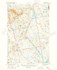
Tomah Stream dominates the central landscape of this Washington County survey, winding through a network of brooks and wetlands that defined the local timber and trapping economy during the early 1940s. The small settlements of Waite and Codyville serve as the primary hubs of activity, connected by roads that traverse the ridges and hills. Numerous seasonal camps and family-named landmarks, such as Keefe Camp, Todd Farm, and the Lamb Place, are scattered throughout the territory, suggesting a lifestyle deeply integrated with the Maine woods. The presence of the Kennebec Dam near the southern boundary and the various flowages indicate the management of water for local industry. The map also delineates several township boundaries, including T 1 R 3 and T 1 R 2, which remain vital for land title research and local history. The northern portion is heavily defined by terrain features like Tomah Mountain and Kane Ridge, providing a clear picture of the area's drainage patterns and topographic character prior to mid-century development.
Find a feature on this map
81 named features on this map. Tap any name to fly to it.
Don’t see what you’re looking for? This feature index may not catch every label — zoom into the map to look around manually.
Map Details
Editions of this 1942 Waite Map
2 editions found
Other maps of this area

1929 · Calais
USGS Topo · 1:48,000

1930 · Vanceboro
USGS Topo · 1:48,000

1932 · Calais
USGS Topo · 1:62,500

1933 · Vanceboro
USGS Topo · 1:62,500

1940 · Danforth
USGS Topo · 1:62,500

1940 · Waite
USGS Topo · 1:62,500

1940 · Forest
USGS Topo · 1:62,500

1940 · Kellyland
USGS Topo · 1:62,500

1941 · Danforth
USGS Topo · 1:62,500

1941 · Scraggly Lake
USGS Topo · 1:62,500