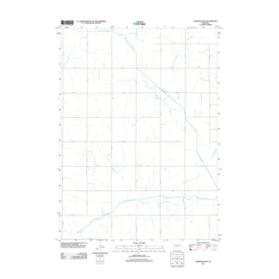
2011 Map of Wakefield SW
USGS Topo · Published 2011About this map
Logan Creek Dredge forms the primary hydrologic spine of this agricultural landscape southwest of Wakefield, Nebraska. The map reveals an area defined by a rigorous section-line grid of rural roads, including Centennial Rd and 580 Ave, which facilitate movement through the intensive farming region of Dixon and Wayne Counties. Several natural drainage systems, such as South Logan Creek, Myrtle Creek, and Dry Creek, traverse the rectangular plots, illustrating how the natural topography of the plains interacts with human-engineered water management. The straight, channelized path of the dredge stands in contrast to the meandering tributaries like Sand Creek and Dog Creek, showing the long-term transformation of the regional watershed to support Nebraska's agricultural economy in the early 21st century.
Find a feature on this map
25 named features on this map. Tap any name to fly to it.
Don’t see what you’re looking for? This feature index may not catch every label — zoom into the map to look around manually.
Map Details
Editions of this 2011 Wakefield SW Map
This is the sole edition of this map. No revisions or reprints were ever made.
Other maps of this area

1955 · Sioux City
USGS Topo · 1:250,000

1958 · Sioux City
USGS Topo · 1:250,000

1959 · Sioux City
USGS Topo · 1:250,000

1963 · Wayne
USGS Topo · 1:24,000

1966 · Altona NW
USGS Topo · 1:24,000

1966 · Altona NE
USGS Topo · 1:24,000
1967 · Allen
USGS Topo · 1:24,000

1967 · Wakefield SW
USGS Topo · 1:24,000
1967 · Wakefield
USGS Topo · 1:24,000
1967 · Concord
USGS Topo · 1:24,000