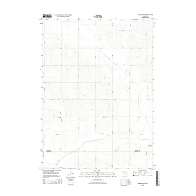
2014 Map of Wakefield SW
USGS Topo · Published 2014About this map
Wakefield marks the southeastern corner of this agricultural landscape, where the boundary between Dixon Co and Wayne Co cuts across the prairie. The terrain is defined by the hydraulic engineering of the early 20th century, most notably the Logan Creek Dredge which runs diagonally through the center of the sheet. This channelization effort is contrasted by the winding remains of the Old Channel Logan Creek, showing how the natural drainage has been straightened for modern cultivation. Small tributaries such as Myrtle Cr, Sand Cr, and Dry Cr feed into the primary waterways, while Dog Cr and S Logan Cr cross the southern sections. A rigid grid of section roads, including Centennial RD and numerous numbered avenues like 577 Ave and 583 Ave, provides access to the surrounding farmsteads, reflecting the enduring township-and-range surveying system that shaped this portion of Nebraska.
Find a feature on this map
34 named features on this map. Tap any name to fly to it.
Don’t see what you’re looking for? This feature index may not catch every label — zoom into the map to look around manually.
Map Details
Editions of this 2014 Wakefield SW Map
This is the sole edition of this map. No revisions or reprints were ever made.
Other maps of this area

1955 · Sioux City
USGS Topo · 1:250,000

1958 · Sioux City
USGS Topo · 1:250,000

1959 · Sioux City
USGS Topo · 1:250,000

1963 · Wayne
USGS Topo · 1:24,000

1966 · Altona NW
USGS Topo · 1:24,000

1966 · Altona NE
USGS Topo · 1:24,000
1967 · Allen
USGS Topo · 1:24,000

1967 · Wakefield SW
USGS Topo · 1:24,000
1967 · Wakefield
USGS Topo · 1:24,000
1967 · Concord
USGS Topo · 1:24,000