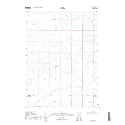
2017 Map of Wakefield SW
USGS Topo · Published 2017About this map
Wakefield sits at the eastern edge of this agricultural landscape where the border between Dixon and Wayne Counties meets. The terrain is defined by an extensive system of waterways and engineering efforts to manage the local drainage, most notably the prominent Logan Creek Dredge. This artificial waterway runs alongside the winding remnants of the Old Channel Logan Creek, illustrating the significant modification of the natural prairie hydrology to support the region's farming economy.
Find a feature on this map
37 named features on this map. Tap any name to fly to it.
Don’t see what you’re looking for? This feature index may not catch every label — zoom into the map to look around manually.
Map Details
Editions of this 2017 Wakefield SW Map
This is the sole edition of this map. No revisions or reprints were ever made.
Other maps of this area

1955 · Sioux City
USGS Topo · 1:250,000

1958 · Sioux City
USGS Topo · 1:250,000

1959 · Sioux City
USGS Topo · 1:250,000

1963 · Wayne
USGS Topo · 1:24,000

1966 · Altona NW
USGS Topo · 1:24,000

1966 · Altona NE
USGS Topo · 1:24,000
1967 · Allen
USGS Topo · 1:24,000

1967 · Wakefield SW
USGS Topo · 1:24,000
1967 · Wakefield
USGS Topo · 1:24,000
1967 · Concord
USGS Topo · 1:24,000